To enumerate, a Measured Building Surveying (MBS) process is a highly accurate, detailed assessment of a building’s dimensions, structure, and features, creating precise 2D plans (floor plans, elevations, sections) or 3D models (BIM) using advanced tech like laser scanners, drones, and total stations. A Measured Building Surveying method provides essential data for architects, engineers, and managers for renovations, new builds, facility management, health & safety, and heritage preservation, ensuring precision and avoiding costly errors by capturing exact layouts, structural elements, and services.
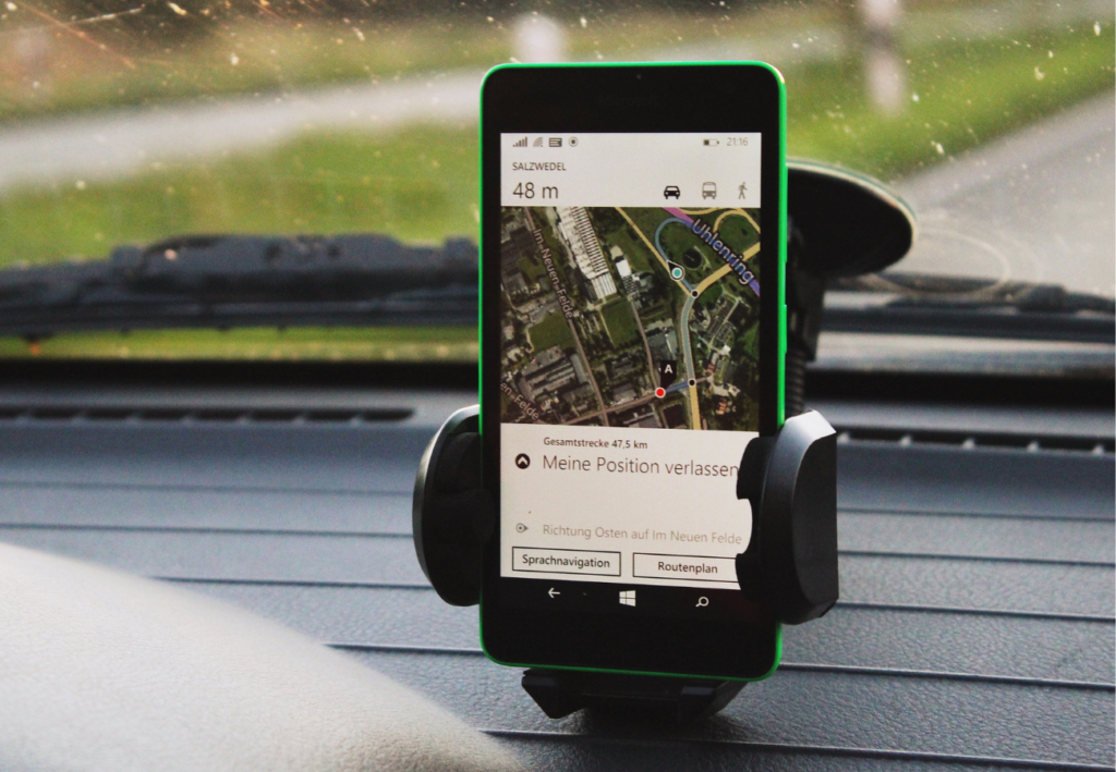
Recently, we have seen an increase in requests for surveying flat roof structures constructed from Reinforced Autoclaved Aerated Concrete (RAAC) planks, primarily at several hospitals, as well as schemes in other sectors. That’s where a measured building survey comes in handy. It helps highlight an accurate depiction of a building. These depictions illustrate all the structural elements and architectural features of the building.

A measured building surveying process can help showcase several different elements: External elevations show the outside façade of a building. On that note, providing a comprehensive range of measured building surveying services ensures we can select the right approach for each individual project – it helps achieve the data you need.
What A Measured Building Surveying Process Entails
Before you can get a hold of fresh dimensions of the building, you will need a building surveyor to help you out with a measured building surveying service for your project. After a research exercise and a visit to the property, accurate drawings can be put together, giving you everything you need to make plans with complete clarity. Measured surveys can vary in detail. A basic survey will include elements such as walls, doors, windows, and level changes. A more complex survey may be 3D laser scanned and include electrical layouts, plumbing, and more precise information.
At Medir Instruments Limited, whether it’s floor plans, sections, structural details, or elevations, we carry out a Measured Building Surveying process on each element of the property, either independently or as part of a fully-connected, coordinated brief. Where appropriate, building surveys can also be carried out in conjunction with topographical or underground surveys.
Across our measured building surveying projects, we use the latest survey technology, including drones, where we need to capture large amounts of data, with minimal interference and often in inaccessible places. We also use 3D laser scanning to deliver high-definition output quickly and accurately, including point clouds and Revit models. 3D photographic records using state-of-the-art imaging are also available to complement technical drawings and data.
1. Area Measuring
Accurate area measurement is critical for property management, leasing agreements, refurbishment planning, and compliance. Whether you’re calculating floor space, determining usable area, or validating space for asset management, having trusted data is essential.
At Medir Instruments Limited, we provide building measurement surveys in full alignment with the RICS Code of Measuring Practice (6th Edition) to all our potential clients. Our work supports commercial decisions, legal documentation, and project planning for buildings across all sectors.
Our surveys typically include:
- Gross External Area (GEA): Measurement of the external face of the perimeter walls, including overhangs and open-sided areas.
- Gross Internal Area (GIA): Measurement to the internal face of perimeter walls, including areas occupied by stairwells, lifts, fuel stores, and entrance halls.
- Net Internal Area (NIA): Measurement of the usable space within a building, excluding perimeter walls, stairwells, lifts, and other non-usable areas.
These measurements are essential for:
- Understanding the area within a building that can be occupied.
- Defining building floor space for leasing and valuation.
- Supporting asset management and facilities planning.
We can also provide detailed floor plans, including building measured surveys and specific areas like fuel stores and open-sided structures, where required. Whether you’re an asset manager, architect, contractor, or building owner, our team delivers fast, accurate, and fully compliant building measurements to support your project at every stage.
2. Building Elevations
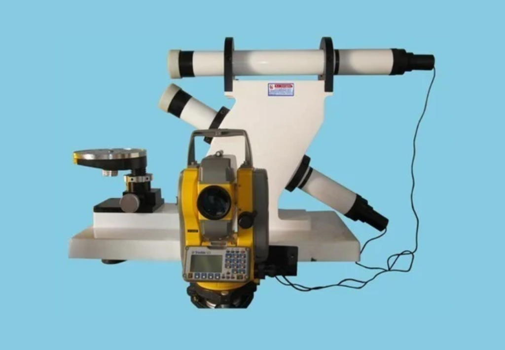
At Medir Instruments Limited, we offer accurate, detailed, and fully measured internal and external elevations of buildings and structures. showing architectural details, construction materials, dimensions, and levels. Depending on the project’s needs, our data recording equipment can include 3D laser scanners, total stations, tape measures, disto, or a drone. With this range of equipment, capturing external features such as doors, windows, glass, downpipes, and guttering, details such as brick and mortar levels are also achievable.
Our survey solutions team can carry out elevation surveys as a standalone project or incorporate them into a wider and more in-depth measured building survey, which can include topographical information, roof and floor plans, as well as sections. Useful for all types of buildings, this data is also helpful for rights of light surveys frequently needed by planners and developers with projects in large towns and cities.
The kind of projects you can measure elevations for may include all types of buildings, from large historic and heritage projects through to private residential schemes. Architects and planners can use the data on the elevations before any modifications to the fabric of the building, for record-keeping purposes, and for cross-referencing when carrying out as-built surveys on new developments.
3. Façade Surveying
A Façade Survey is a vital part of your building maintenance programme. It helps you manage the thermal performance, safety, stability, and aesthetic appeal of your building’s exterior. We use the most suitable technology available to carry out the façade survey, including deploying drone technology for buildings above street level. The advantage of this is the ability to produce a digital twin of the building, allowing engineers and architects to inspect it closely to measure and annotate areas of interest or concern.
Modern building designs incorporate a wide range of cladding materials. External cladding serves a vital purpose, and it is crucial to evaluate the condition and construction of these exterior components. Our façade survey can be conducted on all types of buildings and are the safest, most detailed, and accurate means of inspecting the exterior structural integrity. This assessment helps identify potential defects, ensure legal compliance, and ultimately provides the building with a clean bill of health.
For your information, damaged façades can pose a safety hazard and may expose occupants to weather conditions. Unidentified issues or defects that affect the building’s structural integrity can lead to costly structural repairs in the future. Cracks or gaps can result in poor insulation, affecting energy efficiency. Deteriorating external cladding impacts aesthetic appeal and can lower value.
In many cases, building codes and regulations require regular façade survey inspections to ensure the safety and stability of a building. Failure to comply with these requirements can have legal consequences or result in fines.
4. Floor Planning
We will provide you with fully connected measured floor plans as standalone drawings as part of our measured building surveying service. We work with all types of projects from steel-framed structures through to historic buildings. We use a range of equipment, including laser scanners, total stations, and handheld digital tape measures. Detailed floor plans provide a bird’s-eye view of the entire building, highlighting all its features. This includes ceiling heights, beam locations, window and door heights, their positions and swings, sanitary fittings, structural and stud walls, and floor levels.
Drawings are created for each floor level of the building. You will receive measurements for Gross Internal Area (GIA) and Net Internal Area (NIA). Our drawings are produced in accordance with the 6th edition of the RICS code of measuring practice supplied in 2D format. We can produce 3D CAD plans or 3D Revit models if required. Of course, yes! Gross External Area (GEA) surveys can be included as an additional part of our services.
In addition, we can also create reflected ceiling plans, ideal for refurbishments or new fit-out projects within the retail and commercial sectors. These will include the positions of light fittings, CCTV cameras, smoke detectors, air conditioning units, ceiling tiles, and any other M&E equipment. Roof plans, internal and external, can be produced in conjunction with floor plan surveys. External details will include ridges, parapets, chimney stacks, and skylights. Internal details will include ridges, parapets, chimney stacks, and skylights.
5. RAAC Surveying
Reinforced Autoclaved Aerated Concrete (RAAC) is a material that was used in the construction of schools, hospitals, and other public sector buildings between the mid-1960s and mid-1980s. The physical properties of RAAC differ from traditional concrete, and this may have caused issues with the structural integrity of the roofs in which it has been used.
At Medir Instruments Limited, we support projects across the nation where RAAC plank surveys are needed and/or where RAAC planks need to be identified. We will support you from the very start of the process to carry out assessments of your buildings and assets to understand whether RAAC is present. We have a dedicated RAAC plank investigation team that can visit your site at the earliest possible opportunity and provide an initial assessment as to the presence of RAAC planks.
Your RAAC plank survey will include a full technical site report detailing our recommendations for the next stage. As the largest engineering surveyors, we have established industry partnerships that enable us to offer highly specialist teams able to support every stage of remedial action. Where RAAC planks are identified, combined with signs of spalling and/or deformation occurring, our team can attend the site to gather RAAC survey data for every accessible plank.
Data provided will be in accordance with the Collaborative Reporting for Safer Structures (CROSS) (formerly known as the Standing Committee on Structural Safety). Formats include file types for AutoCAD, PDF, and Excel. A regular maintenance and monitoring programme can be put in place with regular site visits to provide ongoing data monitoring.
6. Section Drawings
Carried out as part of a measured building surveying process, section drawings can supply additional detail to your project by showing a ‘cut-through’ view across the building. Sections are delivered in 2D format for all types of buildings, such as steel-framed structures, through to historic buildings.
Compiled from building data collected from laser scanners, total stations, or drones, cross sections provide extra visual information in conjunction with elevations and floor plans, by showing the thickness of voids between the ceiling in the floor above and the position of the structural walls throughout the height of the building. This detail is used for architects, planners, and developers to support modifications to the fabric of the building.
Sections can be included as part of a fully-integrated measured building surveying process when combined with elevations, floor, and roof plans. Aside from measured building surveying, section drawings are also used to outline ground profiles and structures from site data taken from topographical surveys. They also help in the production of profiles of open watercourses to aid with flood risk assessments.
7. Structural Surveying
Available as a specific investigation or as part of an integrated measured building project, a structural survey will provide you with accurate structural details of key elements in your building or structure. Structural surveys map out and position existing details such as rebar, reinforcement mesh, steel work, alignment of columns, level changes, and the layout of lifts and stairs.
We can also survey inside key building elements, such as floors, walls, and columns, to identify the presence (or lack) of rebar and reinforcement mesh to identify clash risk in previous construction processes. We can provide RAAC plank surveys if the need is identified during the structural survey. During or post-construction, our team of expert surveyors visits your site to undertake an as-built survey to produce drawings for comparison against the original designs.
8. Data Deliverables
Survey data deliverables are the backbone of intelligent planning, design, construction, and asset management. At Medir Instruments Limited, we produce high-quality digital outputs that turn real-world environments into usable, accurate, and fully integrated models for your project team. Our survey data deliverables unlock project value at every stage.
Including:
- Accuracy: Derived from trusted data sources, reducing rework and delays
- Efficiency: Workflows that minimise on-site disruption and maximise digital readiness
- Clarity: Models and visuals that support clear communication with stakeholders
- Compliance: Delivered to specification for planning, approvals, and regulatory requirements
- Sustainability: Insights to drive more energy-efficient and resource-smart decisions
From laser-precise scans to full digital twins, our data deliverables ensure every decision is backed by clarity, collaboration, and confidence. We support clients across infrastructure, commercial, residential, and industrial sectors with a suite of survey data deliverables, including the following:
3D Imagery
Using high-resolution point cloud capture, our 3D imagery provides accurate, real-world representations of structures and sites. This gives design teams, engineers, and stakeholders a visual-first tool to inspect, measure, and plan without multiple site visits.
- Visualise as-built conditions with millimetre precision
- Validate drawings and reduce risk in the design phase
- Export into CAD, GIS, or BIM platforms
Laser Scanning
Laser scanning is the starting point for any detailed spatial understanding. We use industry-leading scanners to collect millions of data points across complex environments, fast.
- Capture internal and external geometry in full detail
- Reduce revisits with complete datasets on day one
- Output to point clouds, mesh models, or Revit-ready files
Building Information Modelling (BIM)
BIM is now a default standard for many asset owners and project teams. We deliver BIM-ready survey data compliant with ISO 19650, enabling digital twins that support design, construction, and facilities management.
- Scan to BIM workflows tailored to your project needs
- Fully coordinated datasets for clash detection and planning
- Structural, architectural, MEP, or civils model options
3D Revit Models
Our 3D Revit models turn survey data into intelligent building models. Delivered to your required Level of Detail (LOD), our models provide the digital foundation for informed project design, compliance, and execution.
- Navigate, slice, and interrogate the model in any direction
- Collaborate across teams with cloud-ready model files
- Generate accurate sections, elevations, and schedules
We deliver survey data deliverables for infrastructure schemes, heritage refurbishments, commercial redevelopments, housing sites, and logistics facilities across the nation. Wherever you need clarity and precision, we bring certainty to your project.
Summary Notes:
Various factors impact the cost of measured building surveying services, such as the level of detail required. At Medir Instruments Limited, we will provide you with options for your project that are transparent and competitive. With locations across the nation, you will be working with experienced professionals in proximity to your location (which will help with managing costs). At the same time, our technical team of surveyors will advise you on the suitable options throughout the process.
Why consult us:
- Trusted by leading clients across the Kenyan border.
- Extensive experience in measured building surveying services and data analysis solutions.
- Fast turnaround with reliable, clear deliverables.
- Measurements suitable for legal, financial, and planning purposes.
To find out more, please visit our Contact Us Page to get in touch with one of our specialist surveyors. Available across our network of nationwide offices, our teams of surveyors share many years’ experience and are in an ideal position to discuss your project in more detail and offer the best measured building surveying services from our broad range of complementary solutions.