Medir Instruments Limited Expert Geospatial Services
Our Team Will Help Optimize Your Surveying And Engineering Projects
Over the years, Medir Instruments Limited land surveying, mapping, and engineering experts have provided exceptional Geospatial Services, meeting all clients’ needs to world-class standards. With that in mind, we deliver extensive services ranging from Conventional Land, Topographic, Geodetic, Cadastral, and Terrestrial LiDAR Surveys.
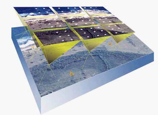
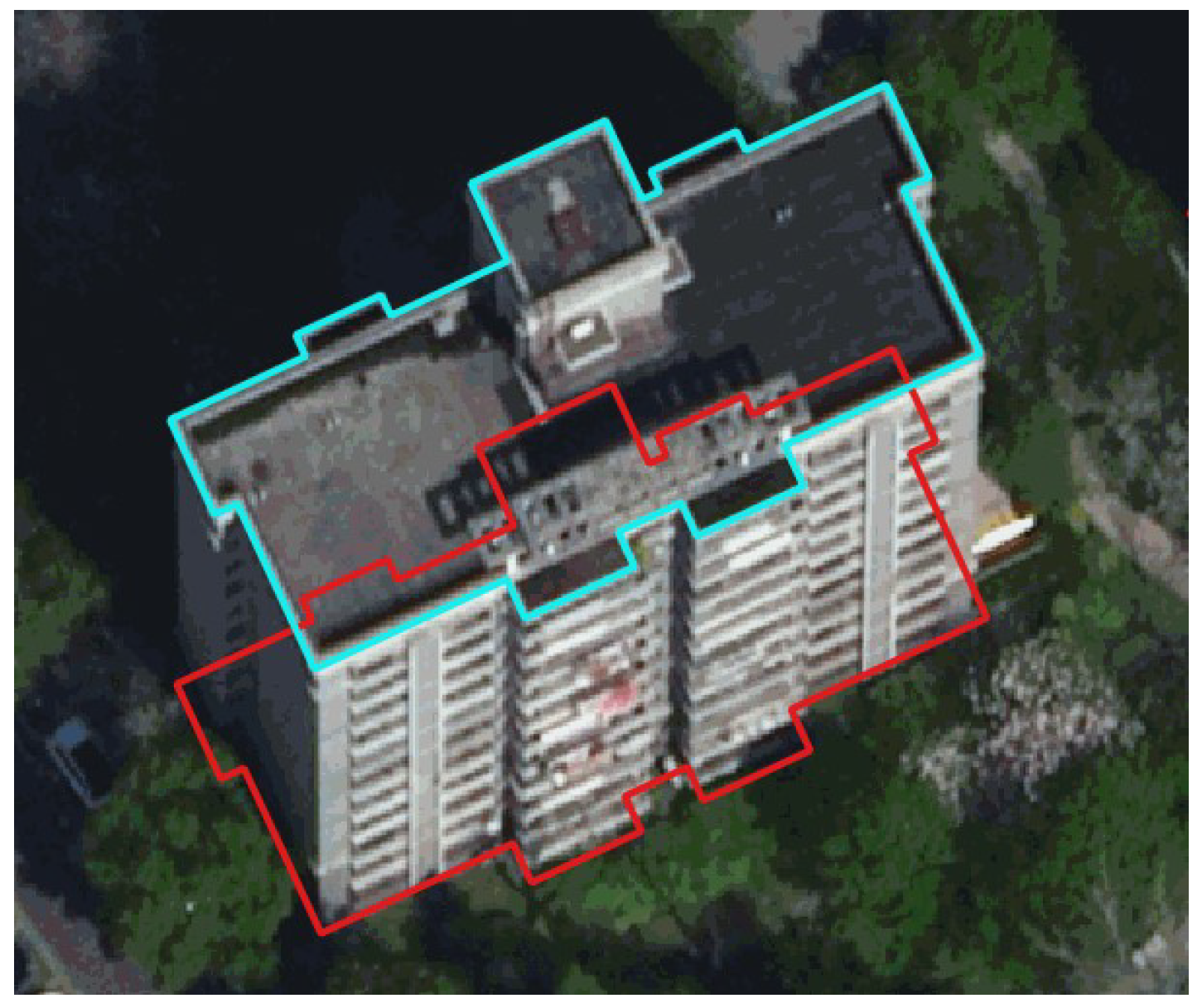
Aerial Triangulation
Automatic Aerial Triangulation is a photogrammetric process that uses overlapping aerial photographs to determine the X, Y, and Z ground coordinates of points, crucial for creating accurate maps and 3D models. The primary goal of Automatic Aerial Triangulation is to establish a precise spatial framework for a set of aerial images, enabling the creation of accurate maps, digital elevation models (DEMs), and other photogrammetric products.
As technology progresses, our understanding of and interactions with geographical data are continuously redefined in the dynamic field of Geographic Information Systems (GIS). Aerial triangulation services and 3D topographical surveys stand out as vital elements in recording, assessing, and visualizing the complicated terrains of our planet among the state-of-the-art instruments reforming the GIS sector. This essay studies modern technologies’ complications, examining their technical features and their transformative effects on different industries.
Smart Notification
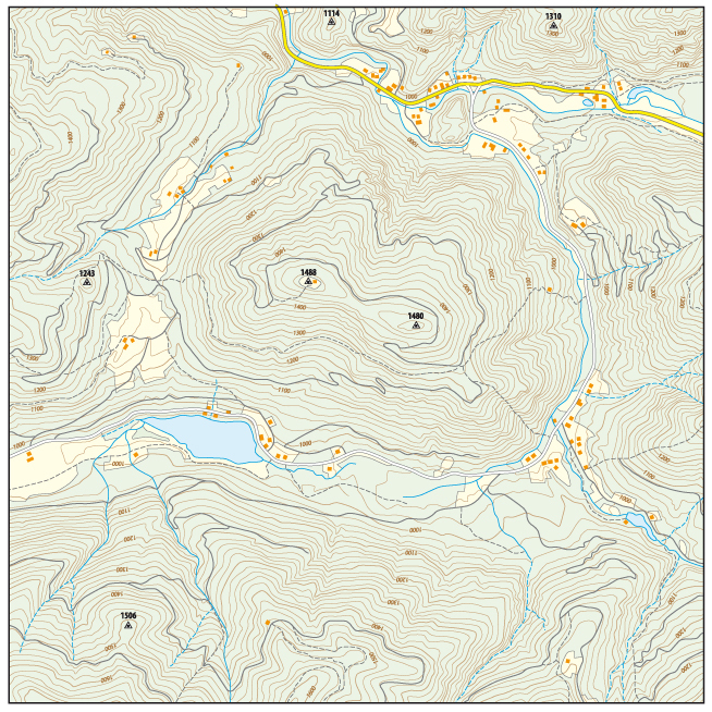
Topographic Mapping
By definition, Topographic Mapping is a method of creating detailed, accurate maps to represent the Earth’s surface features (both natural and man-made elements), using contour lines and other symbols to depict elevation and terrain. A Topographic Map is a two-dimensional representation of a three-dimensional landscape, showing the shape and elevation of the terrain.
Having a Topographic Map is especially important for a proposed land development project. In particular, having a topographic survey plan developed by a surveying company is usually necessary to know how to tie the proposed construction into the existing ground, existing roads, existing drainage systems, and other existing features of the land. This survey would also be used to determine what existing features (such as vegetation) would have to be removed and what would stay after construction.
Digital Terrain Modeling
A Digital Terrain Model (DTM) is a digital representation of the Earth’s bare surface, providing elevation data by excluding natural and man-made features, used for various geospatial and engineering applications. In other words, a DTM is a numerical representation of the terrain’s elevation, essentially a “bare-earth” model.
Medir Instruments Limited specializes in creating highly detailed Digital Terrain Models (DTMs) for a wide range of applications. A DTM is a topographic model of the bare earth, or terrain relief, that contains spatial elevation data in a digital format. The data files are presented as a rectangular grid and vegetation, buildings, and other man-made features are removed digitally.
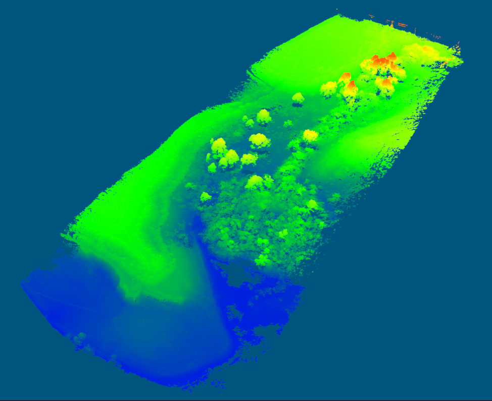
3D LiDAR Technology
Technically, 3D LiDAR Technology is a service that helps engineering and mapping experts in light detection procedures and ranging processes. It uses laser pulses to create highly accurate, detailed 3D maps and models of an environment by measuring the time it takes for the laser to reflect from objects, generating a “point cloud” of data.
Essentially, 3D LiDAR Technology is a remote sensing instrument that uses laser light to detect distances extremely precisely. The device shoots laser pulses in the direction of the Earth’s surface, timing how long it takes for the light to return after striking various objects. LiDAR creates accurate three-dimensional images of the land, buildings, and vegetation by gathering and interpreting these data points. Conventionally, LiDAR Systems collect data in a horizontal plane while operating in a two-dimensional environment.
The General Applications
-
Mapping & Surveying
Creating 3D models of terrain, buildings, and infrastructure.
-
Autonomous Vehicles
Enabling self-driving cars to perceive their surroundings and navigate.
-
Security & Surveillance
Monitoring people flow, detecting threats, and enhancing real-time surveillance systems.
-
Manufacturing Process
Creating 3D models for design, quality control, and robotics.
-
Planning & Development
Monitoring urban changes, assessing infrastructure, and planning for future growth.
Web GIS Mapping
Our company offers a wide range of services driven by an innovative Web GIS System to help organizations make their geospatial data and services easily accessible to others. Eventually, our web GIS services are designed to address a wide range of questions, missions, and problems. We follow a standard software quality assurance framework and all essential steps for software quality assurance and testing are followed from the beginning.
We also provide client site operations testing, performance review & troubleshooting, and training of the complete system. Contact our team today to learn more about how our web GIS services can help your organization. They’ll also help you choose the best service from our extensive web-based GIS systems and product packages.
Smart Notification
Orthorectification
In this case, Orthorectification is a crucial procedure that guarantees the precise alignment of satellite or aerial pictures with the surface of the planet and this process explores the relevance, underlying principles, and detailed Orthorectification procedure delving deeply into its complexities. Using precise technical terms from the GIS field, it seeks to improve GIS researchers, professionals and fans’ comprehension of Orthorectification where geospatial data is essential in many areas of modern decision-making such as agriculture, urban planning, environmental monitoring and disaster management.
The Orthorectification process ensures that imagery is positioned correctly on the Earth’s surface which is crucial to the accuracy of this data and the purpose of this process is to clarify the meaning and procedure of Orthorectification within the framework of GIS.
Drone Mapping
Drone Mapping, also known as drone surveying, uses unmanned aerial vehicles (UAVs) to collect aerial data, creating detailed maps and models for various applications like infrastructure, construction, and environmental monitoring.
3D Drone Mapping is efficient and a lot more cost-effective than traditional alternatives. It can be especially useful for creating maps of hard-to-reach or hazardous locations, minimizing the need for the area to be walked on foot and thereby increasing safety.
Smart Notification
Land Subsidence Mapping
Land Subsidence refers to the gradual sinking or settling of the ground’s surface. It can be caused by a variety of factors, including groundwater pumping, soil compaction, and natural geologic processes. In urban areas, it can lead to damage to buildings and infrastructure, and can also increase the risk of flooding. To address land subsidence, it may be necessary to implement management strategies such as reducing groundwater pumping, improving drainage, and stabilizing soil through the use of compaction grouting or other techniques.
To see success in the Land Subsidence Mapping process, Geospatial Technology plays a crucial role in understanding and managing land subsidence. Our state-of-the-art tools and techniques can provide detailed mapping and analysis of subsidence-affected areas. We use satellite imagery, LiDAR, and other remote sensing data to create highly accurate Digital Terrain Models (DTM) and Land Use and Land Cover (LULC) maps.
3D Infrastructure Modelling
Delving deeper into the nature of the 3D Infrastructure Modelling process, the professional engineering and surveying team from Medir Instruments Limited excels in accurate cartographic feature extraction, which means the whole process of identifying and capturing geographical features from sources such as maps / other spatial data and further converting them into digital data for the purpose of representation.
The 3D Modelling Process entails some unique infrastructure design models which have an important role to play in the simulation of new structures. Usually, the precise measurements and analysis enables various stakeholders to easily visualize future projects before they materialize. Be that as it may, the significance of Medir Instruments Limited in terms of infrastructure mapping and building height assessment must not be forgotten!
Smart Notification
Land Use/Cover Mapping
Our state-of-the-art tools and techniques allow us to provide detailed Land Use/Cover Mapping information and analysis of land use and land cover in any region. By definition, land cover mapping is the process of understanding the surface area of any region with respect to the change that is happening over a given period of time. It classifies land into different categories, such as urban areas, vegetation, cropland, barren land, and water bodies. These maps provide valuable information for the conservation of natural resources, urban planning, disaster management, research, and agriculture.
Land Use Mapping, on the other hand, defines the purpose of the land, whether the land is used for infrastructure, public infrastructure, wildlife, or a protected zone etc. This knowledge will help in developing strategies to balance conservation, conflicting uses, and developmental pressures.
Pan Sharpening
Generally speaking, Pan Sharpening is a vital technique in the field of Geographic Information Systems (GIS) that plays a pivotal role in enhancing the quality and accuracy of satellite imagery. At Medir Instruments Limited, we are at the forefront of utilizing cutting-edge technology in spaceborne imaging sensors to provide our clients with high-resolution multispectral (MS) and panchromatic (pan) images. These images are invaluable for a diverse array of applications and pan-sharpening is one of the key processes that we employ to extract maximum value from these datasets.
Our team of experts is well-versed in the intricacies of pan-sharpening, a method that combines the finer spatial details of panchromatic images with the rich spectral information present in multispectral data. This fusion process results in imagery that not only boasts high resolution but also captures a wealth of spectral information. The result is a comprehensive dataset that can be used for a wide range of applications, from urban planning and infrastructure development to environmental monitoring and precision agriculture.
Access And Monitoring
Environmental Impacts
In terms of urban planning and development processes, 3D LiDAR Technology is used to help capture vegetation, constructions, and infrastructure with remarkably high precision, which helps the creation of in-depth models. This is because understanding the vertical dimension in urban planning is critical sometimes. Thus, the process facilitates the visualization and analysis of urban environment spatial layout by city planners, leading to better-informed decision-making.
An important part of environmental monitoring is assessing the health and structure of the vegetation. 3D LiDAR shines when it comes to collecting exact data on forests, such as tree height, canopy structure, ground cover planning, conservation efforts, and evaluating biodiversity benefits from environmental data.
Innovative And Sustainable Services
From engineering design and manufacturing support to aftermarket services, we partner with our customers to deliver the next generation of products, networks, and systems. Our customer satisfaction audits give us consistently high ratings around technical expertise, execution ownership, on-time delivery, communication, meeting commitments, and client-centricity. As a result, we continue receiving customer and industry recognition for our work.
Software Development
We develop test, implement and support IT solutions that meet and exceed you needs; defined and tested by you!
Spatial Planning
We provide baseline surveys, spatial planning and implementation services to Governments, NGOs and developers in urban and real estate development
Satellite Observation
Satellite Observation data offers the potential to monitor events on earth continuously and accurately without the need for targeted physical surveys.
GIS & Remote Sensing
Make most of your GIS data. We facilitate development, capacity-building and Integration of GIS in to your business processes
Diverse Engineering
We provide Environmental Impact assessment services to a wide range of industries: Construction, Renewable Energy and Exploration.
Underground Mapping
offers tailored underground mapping solutions to help utilities, municipalities, oil and gas, and other infrastructure planners gauge the precise depth and configurations of buried assets before they start excavation.
Spatial Analysis
We support you make the best informed decisions based on location. Make the most of location; stand above the rest.
LiDAR Computing
LiDAR data contains accurate location and height—features such as houses, power lines, and roads are represented in 3D, exactly as they appear in the real world.
Geospatial Modeling
As an end-to-end provider of geospatial solutions, we leverage the full potential of geospatial technologies combined with our global delivery model and agile processes.
Data Acquisition
Our data acquisition capabilities allow us to capture high-resolution aerial and LiDAR data from fixed- and rotary-wing platforms. We also support vehicle-based mobile laser data capture.
Sustainable Planning
We develop business sustainability solutions that respond to your challenges, and enable you to implement your custom strategy effectively.
Applied Research
Knowledge is power. We provide market research, needs assessment, market intelligence and other forms of applied research. Let the data inform you.
Get Started...
Strategic Planning
We build technology for decision-making. And since space is our domain, we help you plan your future. As such, we provide more than ten years of experience in proven strategic planning.