-

KSh 15,000.00
Secure professional-grade stability on the job site with a heavy-duty 5m Prism Pole Holder that has been engineered to keep your survey setup perfectly vertical and stationary. This essential accessory provides hands-free support for precise Total Station and GNSS measurements.
Essential Elements:
- Universal Compatibility: Securely clamps standard 1-inch to 1.25-inch (25mm–32mm) diameter poles.
- Rapid Setup: Quick-release thumb buttons allow independent, instant leg adjustments.
- All-Terrain Grip: Pointed feet with heavy-duty spurs easily lock into dirt, mud, or asphalt.
- Construction: Premium anodized aluminum or carbon fiber built for harsh field environments.
- Convenience: Collapsible, lightweight architecture includes a rugged canvas transport case
-
KSh 14,000.00
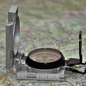
The Professional Geological Transit Compass is the gold-standard instrument for structural mapping, site surveys, and mineral exploration. Combining a precision magnetic compass, a high-accuracy clinometer, and a sighting level, this tool allows for simultaneous measurements of strike and dip.
What’s in the Box?
- 1x Professional Geological Transit Compass
- 1x Heavy-Duty Genuine Leather Carrying Pouch
- 1x Adjustment Tool for Declination
- 1x Instructional User Manual
-
KSh 10,000.00
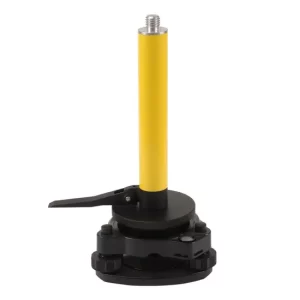
The 25cm RTK Base Extension Mini Pole is a precision-engineered 5/8″ x 11 threaded extension rod designed for GNSS base station setups. Built from high-grade anodized aluminum, it adds exactly 25cm of vertical height to your antenna, providing essential clearance for data cables and reducing multipath interference. Compact, lightweight, and incredibly rigid, it is compatible with all major RTK brands, including Trimble, Leica, Topcon, and CHCNAV.
Field Applications:
- RTK Base Stations: Standard setup for elevating base antennas on tripods.
- Static Surveys: Used in long-duration sessions to ensure stable antenna placement.
- UAV Ground Control: Ideal for setting up GNSS reference points for drone mapping.
- Vehicle Mounts: Can be used as a riser for roof-mounted GNSS receivers.
🛰️ Pro Tip: Always remember to add the 25cm offset to your total antenna height measurement in your data collector software to ensure accurate Z-axis (elevation) data.
-

KSh 900,000.00
The Emlid Reach RS2 is a multi-band RTK GNSS receiver delivering centimeter-level accuracy for surveying, mapping, and data collection. Engineered as an all-in-one land surveying tool, it functions seamlessly as a base station or an RTK rover. It achieves a fast fixed solution within seconds, even under challenging conditions.
Product Highlights:
- Centimeter Accuracy: Delivers precise real-time positioning up to 60 km in RTK mode.
- Multi-Band Tracking: Tracks GPS/QZSS, GLONASS, BeiDou, and Galileo concurrently.
- Built-in Cellular Modem: Features a global 3G/4G modem for uninterrupted NTRIP corrections.
- Long Battery Life: Provides up to 22 hours of continuous autonomous logging on one charge.
- Rugged Engineering: IP67 waterproof and shockproof construction built for extreme fieldwork.
-

KSh 150,000.00
Elevate your layout accuracy with the industrial-grade Ruide Digital Theodolite Series that is designed to streamline structural alignments, anchor bolt placements, and boundary setting. This instrument removes the calculation risks associated with old analog vernier optical scales. The system leverages an automated dual-axis or vertical tilt compensator to actively detect and correct deviation errors, securing reliable readings on uneven ground.
Field-Tested Ergonomics Plus Optics
- Optimized Optics: The high-performance telescope gathers plenty of light, providing sharp imagery across long corridors even during twilight hours.
- Smart Power Architecture: Works with either an eco-friendly rechargeable Ni-MH battery kit or standard AA alkaline cells to guarantee power options in remote zones.
- Universal Tribrach Base: Uses a standard base pattern, letting you clip it securely to heavy-duty wood or fiberglass surveying tripods.
-

KSh 15,000.00
Built from UV‑stabilized, waterproof fabric and a reinforced steel frame, the Survey Umbrell shields total stations, GNSS receivers, and survey crews from sun, rain, and light wind gusts while preserving instrument accuracy. Its quick‑deploy design and universal mounting options make setup fast and secure, so you spend less time fighting the elements and more time collecting precise data.
Key Features:
- Weather Protection — Waterproof, UV‑resistant canopy blocks sun and rain.
- Wind Resistance — Reinforced ribs and vented canopy reduce uplift.
- Universal Mounting — Adjustable clamp fits tripods, poles, and staff.
- Quick Deploy — One‑hand open and secure locking mechanism for fast setup.
- Durable Construction — Powder‑coated steel frame and corrosion‑resistant hardware.
- Compact and Portable — Folds into the included carry bag with a shoulder strap.
Buy the Survey Umbrella for reliable sun and rain protection powered by a UV‑resistant canopy, wind‑stable frame, universal tripod clamp, and compact carry bag from our marketplace storefront today.
-

KSh 10,000.00
The TM-6 Distance Measuring Wheel (Digital) provides 100% accurate long‑run measurements driven by a compact, digital distance wheel for fast, reliable measuring up to long site runs. It features a clear LCD, one‑touch reset, ergonomic handle, and durable tread for construction, landscaping, surveying, and utilities.
Product Highlights:
- Product: TM-6 Digital Distance Measuring Wheel
- Display: Backlit LCD; meters/feet selectable
- Wheel: 320 mm rubber tread for all terrains
- Frame: Foldable powder‑coated steel
- Controls: One‑touch start/stop/reset; unit toggle
- Power: Replaceable coin cell battery included
Technically, it’s ideal for engineering surveyors, mapping contractors, ground landscapers, and facility construction managers.
-

KSh 13,000.00
Eliminate structural drift during critical angle measurements with the Tribrach AJ13 (D1). Purpose-built for demanding land surveying, deformation monitoring, and civil engineering projects, this tribrach forms a highly rigid foundation between your tripod and optical sensors. Its optimized torsional stiffness ensures that the high-speed rotational forces of automated total stations will not introduce alignment deflection or angular errors.
Notable Elements:
- Universal 3-Jaw Interface: Standard forced centering mount compatible with international surveying instrument brands.
- Ultra-Smooth Leveling: Fine-threaded footscrews provide micro-adjustments even under heavy instrument loads.
- Integrated Circular Vial: High-visibility bubble vial simplifies and accelerates baseline setup.
- Torsional Rigidity: Heavy die-cast aluminum frame eliminates structural flexing during rapid instrument rotation.
-

KSh 15,000.00
Buy a durable Wooden Tripod for Total Station and Theodolite use that has a seasoned hardwood, quick-release leg clamps, an integrated bubble level, and a padded carry bag. It’s ideal for surveyors and construction professionals.
Applications:
- Construction site layout and control
- Topographic and cadastral surveys
- Engineering and infrastructure inspections
- Geodetic and mapping projects